

The New Partition of St. Martin: Betrayal or Boon?
.jpg)
It felt like a bold-faced betrayal at first. Then I remembered the infamous Franco-Dutch Treaty which went through a similar process and suddenly the pattern became obvious. It begins with the French having an issue. They invoke the ancient Treaty of Concordia, (which they know was never ratified) and literally arm-twist the Dutch into negotiations that end up in a new bilateral treaty that affects only this territory.
In each case, a St. Martin (South) political leader signs the treaty on behalf of the Kingdom government. In the case of the Franco-Dutch treaty, it was Captain Leo Chance who signed it and for the current delimitation treaty, it was former Prime Minister Silveria Jacobs.
What is it about this 37-square mile island that two European powers not only refuse to relinquish it for five centuries but have actually decided to tighten their grip on it in modern times?
Some would argue that all the colonizers seek is to clarify where their borders stand. Really? And it has taken them five centuries to do so? How did they know since 1648 that one part consists of 21 square miles (the French administered North) and the other (Dutch controlled) 16 square miles? Who did the calculation then and based on what?
Let me state here that there are those of us who really and truly believe that St. Martin is neither French nor Dutch; that it is not “fantastically French and delightfully Dutch,” as a tourist promotional slogan proclaimed in the early 80s. Rather we believe that St. Martin is “one island, one people, (with) one destiny,” as Lino Hughes gloriously sings in his inspirational song, “St. Martin is my home.”
Those of us who believe this to be true - that ours is a borderless island - showed the whole world where we stand with one voice and one flag in the demonstration of September 16, 2020. However, it feels as if all of us have been betrayed now with this new partition treaty, which puts a stamp of division on our island, thus legally ending our historical borderlessness.
For nearly five centuries, this 37-square-mile island divided between France and the Kingdom of the Netherlands has functioned on an extraordinary geopolitical paradox. Our daily existence has been marked by a seamless movement of people, goods and services between the North and South. We have been crisscrossing an open border for centuries. Yet, despite this peaceful daily coexistence, the exact line dividing the two halves of the island was never formally and legally drawn with modern precision.
That historical ambiguity is what is now in its final stages of resolution. On July 16, 2026, the French National Assembly officially ratified the border delimitation treaty originally signed in 2023. This legislative vote marks the completion of France’s domestic approval process, transforming a 378-year-old informal arrangement into a legally binding, technologically “precise” frontier.
article continues below...
The Ghost of Concordia
To understand why they say a new border treaty was necessary in the 21st century, we must return to March 23, 1648. Following the departure of Spanish forces from the island, French and Dutch representatives returned and gathered atop Mount Concordia to sign the so-called Treaty of Concordia.
This 1648 treaty established among other things two critical principles that defined the soul of the island:
1. It partitioned the island into French (northern) and Dutch (southern) jurisdictions.
2. It was a permanent agreement of peaceful coexistence, guaranteeing that the island’s resources would be shared and that people, goods, and property could move completely freely across both sides. In 1648, that “property” included our enslaved ancestors who were not considered human beings.
What the Treaty of Concordia did not do was include a map, geographical coordinates, or explicit technical boundaries in the partition. Instead, the division relied on natural landmarks—ridgelines, prominent trees, old stone walls, and local understandings.
Folklore even attributes the final shape of the border to the myth of a form of early “walkathon” between a Frenchman drinking wine and a Dutchman imbibing gin, both walking in opposite directions. While this casual arrangement sufficed for a mostly agrarian and sparsely populated colonial outpost, it inevitably clashed with the realities of modern statehood, property administration, and economic development.
If the border lacked precision, why did it take nearly 400 years to formalize? Paradoxically, the very success of the island’s open-border culture delayed the need for an official treaty. Because the frontier was entirely open — with no immigration, no customs, no walls, or passport checks — the lack of an exact line rarely disrupted daily life. A de facto boundary emerged over the centuries, governed by custom rather than codification.
But this legal vacuum eventually became problematic. The tipping point arrived at Oyster Pond, a sheltered bay on the eastern coast.
For decades, the Dutch maintained that the entirety of the water inside Oyster Pond fell under their jurisdiction. This allowed businesses like the iconic Captain Oliver’s to operate under the economic permits and tax structures of St. Martin (South), even though the restaurant’s land access sat on the northern French controlled side.
In 2014, French authorities challenged this status quo, executing tax and law enforcement checks on Captain Oliver’s. The resulting diplomatic friction strained local relations and culminated in France formally registering a border dispute with the United Nations in December 2017.
The absolute catalyst for change, however, was Hurricane Irma in September 2017. The storm devastated 95% of the island's infrastructure. When the time came to clear shipwrecks, dredge the bay, and rebuild ruined properties in Oyster Pond, both governments found themselves legally paralyzed. Neither side could issue building permits or clean up environmental debris because neither could definitively prove where their sovereign authority ended. Rebuilding required legal certainty, forcing Paris and The Hague back to the negotiating table. But this argument begs another question: how were the clean up efforts handled in the aftermath of the many other hurricanes and natural disasters that hit the island prior to Irma in 2017?
Local Direct Input
According to reports, the development of this new partition treaty featured significant local participation. While international treaties legally fall under the constitutional purview of the Kingdom of the Netherlands (handled by the Ministry of Foreign Affairs), the actual parameters of the agreement were negotiated directly by local officials.
Following nine years of delicate, quadripartite talks involving the governments of the Republic of France, the Kingdom of the Netherlands, the Collectivity of Saint-Martin, and the Government of St. Martin (South), a compromise-driven framework was finalized.
On May 26, 2023, then-Prime Minister of Sint Maarten Silveria Jacobs signed the historic document at Belle Plaine/Belvedere on behalf of the Kingdom, alongside French Minister of the Interior and Overseas Territories Gérald Darmanin. Jacobs explicitly noted that Sint Maarten had been "in the lead and wholly involved" from day one, ensuring that local ministries (including VROMI, Justice, and Tourism), as well as local cadastral data, dictated the terms.
Touting this local involvement in the elaboration of the new partition treaty leads one to conclude that we are blessed with top-notch expertise that has been able to negotiate a very complex and highly technical landmark international treaty. This should bode well for an independent St. Martin!
The New Frontier
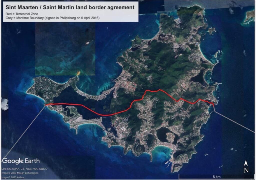
Some experts who have reviewed the new treaty indicate that it does away with historical guesswork by defining a single, legally continuous frontier that ties together the island's existing land and maritime borders.
They claim that the new treaty also maps out the line from Point D on the eastern coast to Point C on the western coast, establishing a grid anchored by 392 specific land-boundary points and 15 distinct coordinates inside the Oyster Pond area. Every consecutive point is connected by a straight geodetic line utilizing modern international reference systems.
The core of the compromise centers on a strategic exchange of territory to resolve historical anomalies:
The Oyster Pond Solution
Another feature of the new treaty is that the border through Oyster Pond now formally adopts the internationally recognized principle of equidistance, cutting cleanly through the center of the bay. Under this definition, France has gained formal water rights and jurisdiction over a portion of Oyster Pond, which includes the area containing Captain Oliver’s.
The Land Mass Compensation
To balance the scales and maintain the overall geographical equilibrium of the island, the southern Dutch controlled side received territorial concessions on land. It formally gained 7,109 square meters of land mass spread across various contested pockets along the 10-kilometer frontier.
What the Treaty Accomplishes
Some people with good knowledge of the text of the 17-article treaty claim that it goes far beyond merely mapping coordinates; it serves as a modern administrative blueprint for a shared island.
Property Registration and Business Continuity:
It establishes exactly which civil, tax, and commercial laws apply to properties built near the line. Businesses that found themselves shifted from one jurisdiction to another now have a clear legal transition framework.
Maritime Rights and Navigation:
The agreement guarantees mutual rights for vessels flying both French and Dutch flags. It explicitly secures freedom of navigation, anchoring, and traditional fishing rights within the shared waters of Oyster Pond and the Simpson Bay Lagoon.
Joint Environmental and Disaster Management:
By establishing explicit jurisdiction, the treaty unlocks potential joint public funding and clear administrative permits for lagoon cleanups, coral reef protection, and synchronized emergency responses to future hurricanes.
The Mixed Commission:
To prevent future disputes, the treaty creates a permanent, joint bilateral body. This commission has the direct authority to maintain physical border markers, inspect frontier zones, and propose technical adjustments to coordinates if infrastructure changes require them. However, the composition of this Commission has not been made public as far as I know.
Preservation of Open Borders:
According to officials, a crucial aspect of the new treaty is that it codifies the spirit of the Treaty of Concordia. It provides absolute legal certainty to the states while keeping the border entirely open, ensuring that the local reality of "one island, one people" remains completely untouched.
The Next Steps
While the French National Assembly’s vote on July 16, 2026, represents a massive step, the treaty is not yet in effect. Because international agreements of this scale involve a sovereign, multi-country kingdom, the approval process follows a strict constitutional route across the Atlantic.
The next and final steps rest entirely with the Kingdom of the Netherlands. Under Article 3 of the Statuut voor het Koninkrijk der Nederlanden (the Kingdom Charter), foreign relations are classified as a collective Kingdom affair. However, because this specific treaty directly establishes "gelding" (territorial applicability) for St. Martin (South), the constitutional machinery requires transparency and check-and-balance involvement from all the partners in the Dutch Kingdom.
According to Article 24, paragraph 1 of the Statuut, any treaty concluded by the Kingdom that affects Aruba, Curaçao, or St. Martin (South) must be submitted concurrently to the Dutch Parliament and to the respective Parliaments of Aruba, Curaçao and St. Martin (South).
This triggers a precise legislative process under the Kingdom Act on Approval and Publication of Treaties:
1. Concurrent Review: The treaty is formally presented to the parliaments of Aruba, Curaçao, and Sint Maarten at the same time.
2. St. Martin's Primary Domain: Because the border demarcations affect St. Martin (South) exclusively, its parliament has direct legislative prominence. The government of St. Martin (South) has reportedly completed its internal structural evaluations and signed off during initial negotiations.
3. The Kingdom Vote:
While the final binding vote to ratify the Kingdom Law occurs within the Dutch Parliament in The Hague, the Ministers Plenipotentiary of Aruba, Curaçao, and St. Martin (South) sit in the Kingdom Council of Ministers to represent the positions of their respective islands. Furthermore, these Parliaments maintain the statutory right to review the document and issue a formal position report before the final vote is cast in the Netherlands.
Once the Kingdom Parliament completes its final vote of approval, and the formal instruments of ratification are officially exchanged between Paris and The Hague, the treaty will enter into force. When that occurs, St. Martin (North) and St. Martin (South) will possess a single, legally unbroken, and globally recognized frontier stretching from the Atlantic waters east of Oyster Pond, cutting across the hills, and diving back into the Caribbean Sea.
The Role of our Parliament
The Parliament of St. Martin (South) must absolutely have its say before this treaty can legally bind the island. Although the government signed off on it during negotiations, that simply means the negotiators of the executive branch agreed to the text. Under the constitutional framework of the Kingdom, the executive branch cannot bypass parliament to permanently alter borders or pass laws.
1. The Power of Article 24 of the Statuut
Under Article 24, Paragraph 1 of the Statuut, or Kingdom Charter, a treaty that affects St. Martin (South) cannot just be quietly ratified in The Hague. It must be submitted to its Parliament at the exact same time it is submitted to the Dutch Parliament. The Parliament of St. Martin (South) has a specific period of time to review the exact, final text that the French National Assembly just ratified.
2. The Silent Approval vs. Express Approval Mechanism
Under Kingdom law, treaties are often approved via a "silent procedure" (stilzwijgende goedkeuring). That is to say, if no parliament objects within 30 days, it passes.
However, Article 24, Paragraph 2 of the Statuut gives the Parliament of St. Martin (South) a major lever. If it decides it wants a formal, structural debate on this treaty, it can demand express approval (uitdrukkelijke goedkeuring). If they invoke this, the treaty cannot move forward on a silent track; it forces an explicit legislative vote.
3. The Special Delegate (Article 28)
If the Parliament of St. Martin (South) is unhappy with the final text or how it impacts local land and businesses, they don't just write a letter. Under Article 28 of the Statuut, it has the constitutional right to send special delegates directly to the Dutch Parliament in The Hague.
These delegates have the right to:
a. Sit in on the debate in the Dutch Second and First Chambers.
b. Speak on the floor of the Dutch Parliament to defend the island’s interests.
c. Propose amendments to the Kingdom approval law.
As things stand at the moment, the ball is in the court of our Parliament. Will they quietly allow the new treaty to be ratified silently or will they trigger the express approval mechanism and call for a parliamentary debate on the treaty? Has our parliament even received the new treaty and if so have our MPs read it? The example of the Franco-Dutch treaty should be instructive in this case.
I definitely would think that a treaty of this nature should be meticulously debated by our parliament because of its life-changing impact on our way of life. Despite assertions to the contrary, can either side actually guarantee that they will not close their borders again?
Besides, what impact could the treaty have on a possible reunification of the island, or is that a pipe dream for those of us who believe in a one, united and indivisible St. Martin nation?
And for the independentistas, how will the new partition treaty (shall we call it the “Belle Plaine/Belvedere Treaty”) affect the struggle for an independent St. Martin?